• Begin
  • KY
  • TN-NC
  • Georgia
  • FL
John Muir's southern Trek, 150 Years
  • Begin
  • KY
  • TN-NC
  • Georgia
  • FL

150 Years Later:
​A Conservationist's Observations

Sesquicentennial


As 2017 is the sesquicentennial year for John Muir’s thousand-mile walk across the southeastern U.S. (1867-68), it is likely that many people will be attempting to trace his path. After largely retiring from a forty-year career as a land and environmental conservation professional in the same region of our country, I've been inspired to retrace the path of Muir’s long walk myself, but with a different focus—that being by telling the story of land conservation along the route of Muir's Southern Trek.  An account of conserved lands and protected natural areas along Muir's Southern walking route fits nicely with the mission of the organization for which I now serve as president -- Southern Conservation Partners -- which is dedicated to enhancing protection, restoration, and greater public awareness of the natural heritage of the southern U.S.

At my age, I was not particularly interested in walking 1,000 miles on road shoulders. I had no interest in recreating Muir’s rapid pace (practically a self-imposed forced march) and starvation rations—let alone contracting malaria along the way as Muir did! I would not literally hike the whole route of the then 29-year-old John Muir, but I decided to take a different perspective on his adventure. I would follow Muir’s route largely by personal vehicle, with periodic short walks along the way. I segmented my examination of his route into sections spread over more than a year.

My intent was to observe and describe the publicly accessible parks, nature preserves, forests and wildlife management areas, and other recreational areas along Muir’s walking route, in homage and testimony to the success story of land conservation in the southeastern U.S.  I hope my account may educate and inspire others to enjoy 21st-century natural assets, many of them protected, along the route John Muir took 150 years ago. I intend this to be a short story on the progress of land conservation in the southern U.S.

I welcome your suggestions for improvements to this account!  Please offer your suggested additions or corrections directly to me.     
Picture
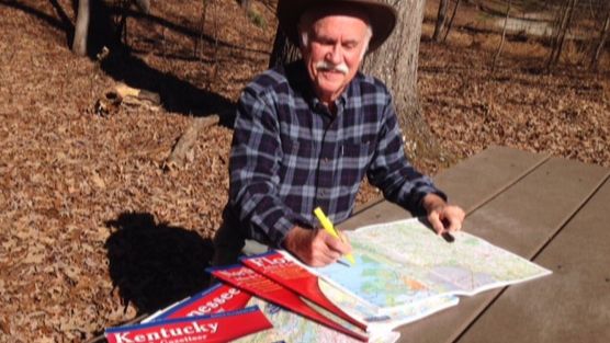
Author of this Story: Chuck Roe
Roe’s professional career includes being the founding manager of the North Carolina Natural Heritage Program, founding director of the Conservation Trust for North Carolina, and Southeast U.S. Region program director for
the Land Trust Alliance. Contact him HERE. 
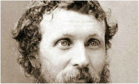
Picture
John Muir
My principal guide for this project
is John Muir’s own memoirs of his
journey, composed years after his trek
from his notes, which were edited and
published posthumously in 1916 as

A Thousand-Mile Walk To the Gulf.
Picture
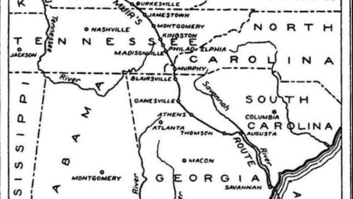
Get Started on the Route
View the map published with Muir's A Thousand-Mile Walk to the Gulf, and begin reading Chuck Roe's exploration of the route . . . or use the menu at top of this page to read by state.
Explore

O V E R V I E W

John Muir's Inspiration


John Muir decided to take his impromptu hike across the southeastern U.S. less than two years after the American Civil War had ended. He was 29 years old. The son of Scottish immigrants, Muir had no interest in his parents' hardscrabble lifestyle farming the poor sandy soils of glacially-scoured Wisconsin. But his interest in biology grew during his years as a student at the University of Wisconsin in Madison. He proved there to be a creative inventor, scholar in topics of interest to him, and an eccentric character. He avoided being drafted into Civil War military service by taking temporary refuge in Canada for the duration of the war. 

Immediately after the war he took a factory job in Indianapolis. After recovering his eyesight from a serious industrial accident that temporarily blinded him, and before  moving on to California, where he eventually would earn renown as America’s foremost advocate for wilderness preservation, he decided on a whim to undertake a walk across the southeastern U.S. and then perhaps on to South America. His route began by foot from Louisville, Kentucky, to Savannah, Georgia. After a boat voyage from Savanna to Fernandina in extreme northeastern Florida, he then walked on across the peninsula to Cedar Key on Florida’s Gulf Coast. After a bout with malaria, he hitched a ride to Cuba on another boat. Extreme poverty and life-threatening malaria interrupted his itinerary. He jettisoned his original intent to forge onward into South America and instead traveled to California, and the rest of his life story.

On September 2, 1867, Muir crossed the Ohio River by train from Indiana into Louisville, Kentucky, with only a vague notion for the route of his Southern Trek and carrying only the clothes he wore and a simple rucksack containing the barest of necessities, a Bible for reading, and a rude plant press in which to place his botanical collections. It was a true adventure for an itinerant naturalist: he carried little money and he depended on the kindness of strangers to provide him food, lodging, and passage over larger rivers. His demeanor was apparently so interesting and eccentric that many along his path did offer food and lodging—although many nights he slept on his bed roll in the open. When he encountered desperadoes and guerrilla bands that plagued the countryside in the wake of the Civil War, they sized him up as an impoverished, strange “herb collector” and passed by without harming the wanderer.

Muir walked from Louisville, Kentucky, along existing rough roads and paths that over time have been succeeded by modern highways. America’s roads and highways often evolved along the same routes as early Native American trails, early settlement horse and wagon paths, and a succession of roads and bridges. In most places today, Muir’s walking path has been replaced by state and federal roads—even interstate highways. Railroad lines constructed later in the 19th and the early 20th centuries parallel roads on several sections of Muir’s route. Muir stuck to established roads and pathways in valleys and through mountain passes. He did not leave existing trails to climb over mountain summits or down into the chasms of river gorges. To cross streams and rivers, he sought out shallow fords, the few existing bridges, or public ferries. Following Muir’s walking path today is an interesting study in the development of America’s highway and bridge transportation system.

Following Muir’s trek today also allows us to examine the progress of land conservation in the Southeast. One encounters many natural areas and parks that have been protected by combined efforts of private land conservation organizations and state, national, and local public natural resource conservation agencies. This account is meant to celebrate a story of success in land conservation in the southeastern U.S.— a story that could be duplicated along other 1,000-mile-long transects across this region. I encourage others to follow the route of Muir’s 1867-68 walk and to learn from and enjoy the many accessible public recreation and environmental assets that have been protected along that route.​ 

Note of appreciation:  I am grateful to Laura M. Cotterman for her editorial skills and formatting assistance.
Picture
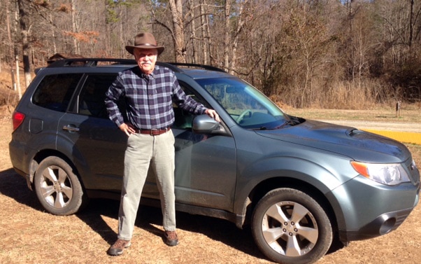
Chuck Roe and his Subaru Forester.
Powered by Create your own unique website with customizable templates.
  • Begin
  • KY
  • TN-NC
  • Georgia
  • FL